|
Special
Reports/Water Crisis |
Designing Mirani Dam for local needs
By Sikander Brohi
Water is a scarce commodity in Balochistan. Since long,
communities have evolved indigenous institutions for
regulating the use of this resource which essentially
comprises of surface flows in ephemeral streams , spring water
channelled through karezes and groundwater extracted through
surface wells and tube wells.
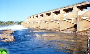 Inadequate resources have propelled the government to
construct the Mirani Dam across the Dasht River. It envisages
provision of dependable irrigation supplies for the
development of irrigated agriculture on the two banks of the
river. Inadequate resources have propelled the government to
construct the Mirani Dam across the Dasht River. It envisages
provision of dependable irrigation supplies for the
development of irrigated agriculture on the two banks of the
river.
Dasht River is a non-perennial stream. Its flow depends on
rainfall in the catchment area whose annual average is 4.2
inches. The project would be completed by 2006 with a cost of
$101 million.
Though, it is being claimed that projects like the Mirani Dam
would bring socio-economic changes, however, in practice the
case seems to be averse. Policy makers neither bother to
involve the common people nor do they keep their interests in
mind while designing such projects.
Such is the case with the Mirani Dam. The feasibility report
was completed in 1956 and the work began in 2001, and that too
after the commencement of the Gwadar Deep-sea Port with the
objective to provide water.
While designing the dam's height and storage capacity no
consideration was given to minimizing the inundation of the
local areas and populations. According to experts and local
communities, a population of 50,000 is to be affected in the
upstream of Dasht River as a result of the storing floodwater
in the dam.
According to estimates, the majority of the population of
Nasirabad, Nodiz and Kalatuk would be inundated once the water
was stored in the dam to full capacity. These claims can be
substantiated from the original project survey of 1956.
The dam's height in the original design was 80 feet not the
present designed 127 feet. However, the survey had shown at
least two Union Councils i.e., Nodiz and Nasirabad to be
inundated as a result of the commissioning of the dam.
The dam is aimed at irrigating about 33,000 acres of land.
However, its commissioning is already destroying millions of
acres of cultivated land with 18 tube wells, five Karizes and
many other irrigation infrastructures. Despite such
destruction and possible inundation, so far, owners of only
6,700 acres have been provided compensation, while 18,981
acres await compensation.
The compensation provided is also not appropriate.
Accordingly, communities in the case of Sabakzai Dam in Zhob
district received compensation at Rs43,560 per acre, while the
Mirani Dam affectees are being paid Rs15,000 to 20,000 per
acre, only.
Besides, a vast upstream area including villages, irrigated
lands, infrastructures including tube wells would face the
menace of water logging and salinity. Interestingly, even
after more than three years of work on the project no
scientific survey has been undertaken to ascertain the extent
of damage.
The commissioning of the dam will threaten the atmosphere of
social cohesion in the region as lands close to the dam have
been deprived of irrigation water as per design. According to
the design, the dam is supposed to provide water to the lands
at least 5km away.
For example, important areas of Bandgah, Hamlani and Sangai on
the left bank of Dasht River would be deprived of water as per
design. Similarly, areas on the Right Bank Canal, deprived of
the irrigation water, include Jalabani, Siahalo, Zore Bazzar
and Pittok.
Although, presently these areas are irrigated, however with
the construction of the dam these lands would also become
barren, causing social conflict between the landowners of
these lands and the lands to be irrigated by the dam water.
The landowners of these areas have already threatened not to
allow the canal waters flow from their area if they are
deprived of the water.
Meanwhile, there is no provision in the dam design for a
floodgate in the downstream of Dasht River, and the outlet
will exist only in the form of the sole spillway with a very
limited capacity.
Due to an inadequate spillway, water would flow very slowly,
thus terminating the flood irrigation in a 150km stretch on
both banks of Dasht River downstream the dam.
Millions of acres of land is irrigated by flood irrigation.
This land is situated in the average 5km width of the river,
which receives river water in the case of flooding.
Millions cultivate crops and fruits like cotton, watermelon,
mash etc., through flood irrigation. These lands would be
degraded due to no flooding in the area once the dam was
operational.
Besides, the flood irrigated lands, the downstream areas are
also characterized with forests, which too, are the resources
of livelihoods for millions. With the decrease in river flows
these forests would be degraded and degenerated, which would
result in the deprivation of livelihoods of a large number of
woodcutters.
The major effect of the reduction in fresh water flows
downstream area of the river would be on the Dasht River delta
area, as reduction in flows would threaten mangrove forests,
ultimately affecting the shrimp catch, a major source of
livelihood for fisher folk communities. The dam project offers
no compensation or alternative livelihoods for those growers,
woodcutters and fishermen of the downstream region.
SUGGESTIONS: Height of the dam should be reduced by at
least eight feet, which would prevent a large number of
villages upstream from being inundated. Similarly, the
proposed storage capacity should also be reduced by at least
15 feet, reducing the flood level by about 6 feet in the
upstream areas, thus preventing vast areas including towns of
Soleband and Nasirabad from being inundated.
A comprehensive survey of villages and lands should be carried
out and a resettlement plan prepared before storing water in
the dam. The affected people should be settled in and around
Gwadar, ensuring some alternative livelihood to affectees.
Owners whose lands are affected should be provided lands in
the dam command area and a scientific survey should be carried
out to know the extent of possible extent of water logging in
the upstream areas once the dam is operational.
The areas and the village to be threatened from the menace of
water logging should also be provided reasonable compensation.
Maximum Dasht River flows downstream the Mirani Dam should be
ensured to save the flood irrigated lands, forests, and
mangroves ecosystem of the Dasht Delta, as well as the
fisheries and shrimp resources of the region.
Courtesy: The Dawn
|
Pakissan.com;
|